Dashboards
Division Web Pages
Watershed Dashboard
New MVD Gage Page ---- CSH Plots
Dashboard Links
Old MVD Gage Page
National Weather Service Links
A2W Reservoir Report
Past Precip Links --- 1 Day --- 3 Day --- 7 Day
District Web Pages
Interactive QPF Map
National Climate Maps
St. Paul
QPF Links ------ 2 Day ------ 7 Day
Rock Island
Drought Monitor
Memphis
River Forecast Links
Vicksburg
NWS NWPS River Forecast Map
New Orleans Salt Water Wedge
Guidance Plots
Little Rock
Upper MSR Contingency Forecast
Tropical Sites
Lower MSR Contingency Forecast
CERA
NWS Forecast Maps
NWS GIS Viewer
Ventusky
KY Lake Guide Curve Releases
National Hurricane Center
BRKLY Lake Guide Curve Releases
Map Viewers
NOHRSC Snow Depth
MMC FIM Viewer
RIM Tool (Rapid Inundation Mapping)
Ohio River Basin Contingency Forecasts (HEFS)
LRN Products
National Levee Database
National Inventory of Dams
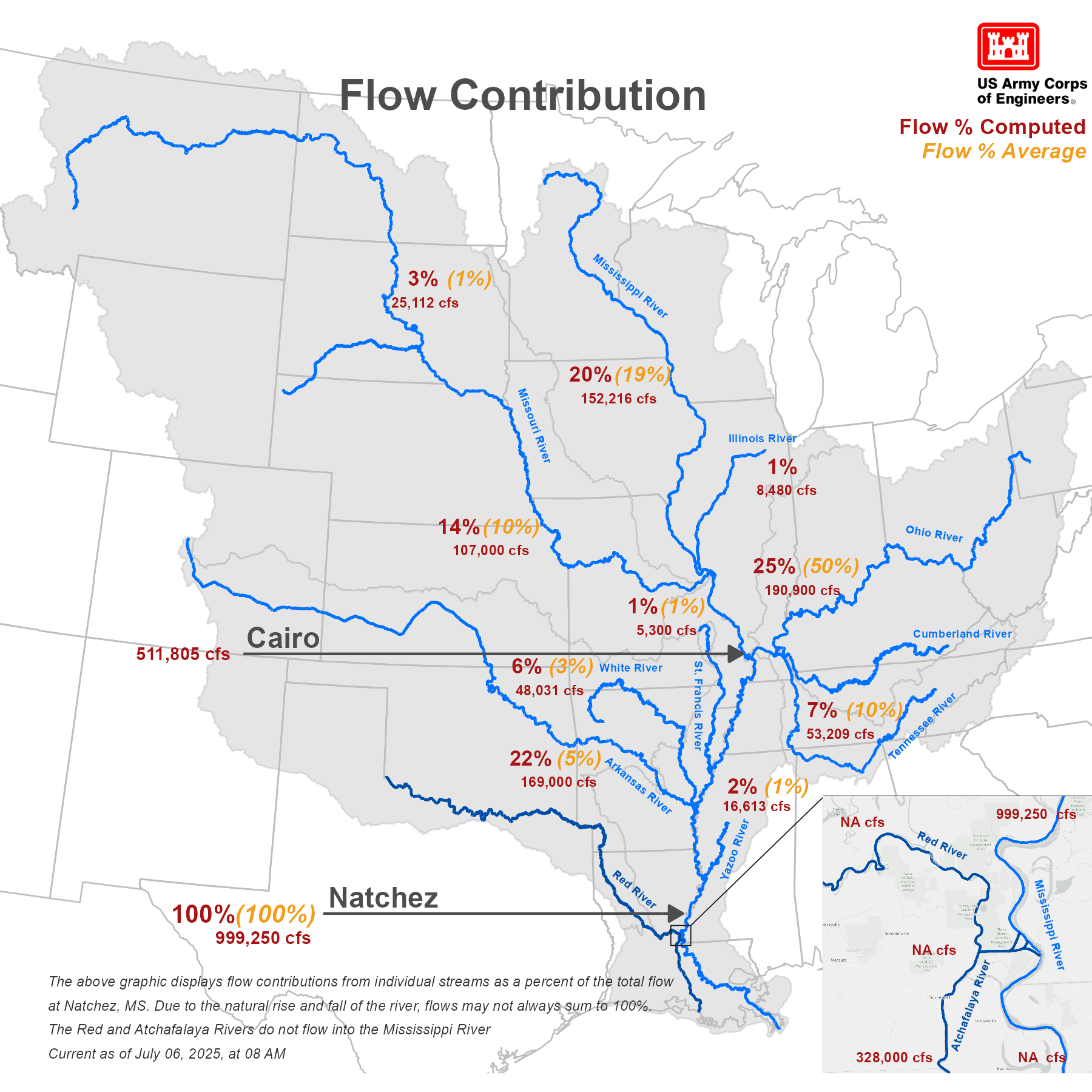
GMRB Flow Distribution
CWMS Implementation Viewer
LMRFC River Summary
Other Links
Missouri River Basin
Missouri River System Storage
FUSION TEAM
RIVERGAGES.COM
INFOGRAPHICS
Precip Trends Paper
NWS Text Products
Access to Water
USGS Links
MVD HH&C CoP Org Chart
USGS Streamer
Watershed Sharepoint
USGS Mapper
USGS FIM Viewer
HQ Sharepoint
HQ Orders
MVD Orders
National Water Dashboard
MVD HH&C Newsletter
USGS Flood Event Viewer
State of the River
Accessibility FOIA Information Quality Act
Link Disclaimer No Fear Act Privacy & Security
USA.gov

