|
Mission Statement
The
Fusion Team mission is to improve the accuracy and utility of
river/rainfall observations and river forecasts. The Fusion Team is comprised
of representatives from the National Weather Service, US Geological Survey and the US Army Corps of Engineers. The team
works collaboratively to identify needed improvements and develop plans
to implement those improvements given the current science, manpower and
level of funding. The ultimate goal is to
optimize the accuracy and utility of the forecasts provided to the
Public in accordance with all applicable regulations.

Welcome
Thank you for visiting the newly
improved Fusion Team website. We hope you find this site useful for
Team collaboration among our member agencies.
2021 MS River Basin Quad-Agency Meeting Scheduled
The face to face meeting is
scheduled for Oct 2021. This will be the first face to face meeting for
the group since 2019. The former Tri-Agency Meeting has been expanded
to include FEMA as a coordinating agency to become the Quad-Agency
Meeting. The meeting is a great forum for agencies in the Mississippi
River Valley to discuss coordination during major flood events,
improvements to each agency's tools and products, on-going studies and
projects, and inundation map development and sharing.
IWRSS iFIM
The iFIM group met daily during Hurricane Zeta. The USACE prepared and issued a dynamic flood-inundation map for the area near and inland of the landfall area. WRSS Fact Sheet
|
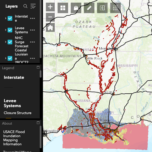
USACE FIM issued after coordination
with IWRSS (NWS, USACE, FEMA, and USGS) iFIM
group.
|
Notice:
All data contained herein is preliminary in nature and therefore subject to change. The data is for general information purposes ONLY and SHALL NOT be used in technical applications such as, but not limited to, studies or designs. All critical data should be obtained from and verified by the United States Army Corps of Engineers, St. Louis District, Engineering and Construction Division, Hydrologic and Hydraulics Branch, 1222 Spruce Street, St. Louis, Missouri 63103-2833. The United States of America assumes no liability for the completeness or accuracy of the data contained herein and any use of such data inconsistent with this disclaimer shall be solely at the risk of the user. |
|